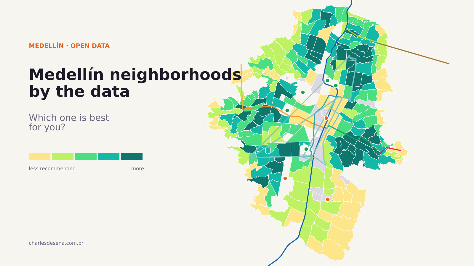
Search for “best neighborhoods in Medellín” and almost every answer says the same thing: El Poblado, Laureles, Envigado. These lists are written from a visitor’s point of view, and they rarely show a single data point.
I wanted to ask the question the other way around: what does the city’s open data say about each of its 249 urban neighborhoods (barrios)? I combined data from the City of Medellín and the Metro on safety, transit, shops, health care, schools, sports facilities and land prices. The result is an interactive map where you decide what matters, and a ranking with a few surprises.
The map: choose what matters to you
Pick a profile (balanced, family, nomad or budget) or move the sliders yourself. The map and the top 10 update instantly. Hover over a barrio to see its profile, or search for it by name.
What the data shows
1. The most balanced barrios aren’t in El Poblado. With the balanced profile, which weighs safety double and everything else equally, the top 10 is made up of estrato 2–4 barrios such as Tejelo and Alfonso López (Castilla), La Esperanza (Doce de Octubre), La Piñuela and San Isidro (Aranjuez), La Mansión (Villa Hermosa), San Bernardo and Las Mercedes (Belén), Gerona (Buenos Aires) and La América. They have few homicides, a Metro or tram stop nearby, neighborhood shops and land that isn’t yet among the city’s most expensive.
2. If price doesn’t matter, the west side wins. Remove price from the calculation and the top spots go to El Velódromo, Los Colores and Florida Nueva (Laureles) and San Bernardo, Fátima, Granada and Rosales (Belén), plus La América. They’re flat, well-served, well-connected neighborhoods with below-average homicide rates.
3. El Poblado is safe, but expensive and far from the Metro. Comuna 14 has one of the best safety scores in the city. But it has the most expensive land, and in 78% of its barrios the nearest station is more than a kilometer away. That’s why it falls behind in any ranking that includes price and transit. If price isn’t a concern, it’s still a good option.
4. For families: Laureles and Belén. With more weight on safety, schools, sports facilities and quiet streets (few bars nearby), the top includes Los Colores (Laureles), Bomboná No. 2 and Cataluña (Buenos Aires), and San Bernardo and Fátima (Belén).
5. The extremes. The lowest-scoring barrios are La Sierra and Villa Turbay (Villa Hermosa), El Triunfo (Doce de Octubre), and Ocho de Marzo and Juan Pablo II (Buenos Aires). There, safety outweighs any other advantage. Only 27% of the urban population lives within 500 meters of a Metro system station.
Why I didn’t use reported robberies
The figure most often used to call a neighborhood “dangerous” is reported robberies. It’s also the most misleading.
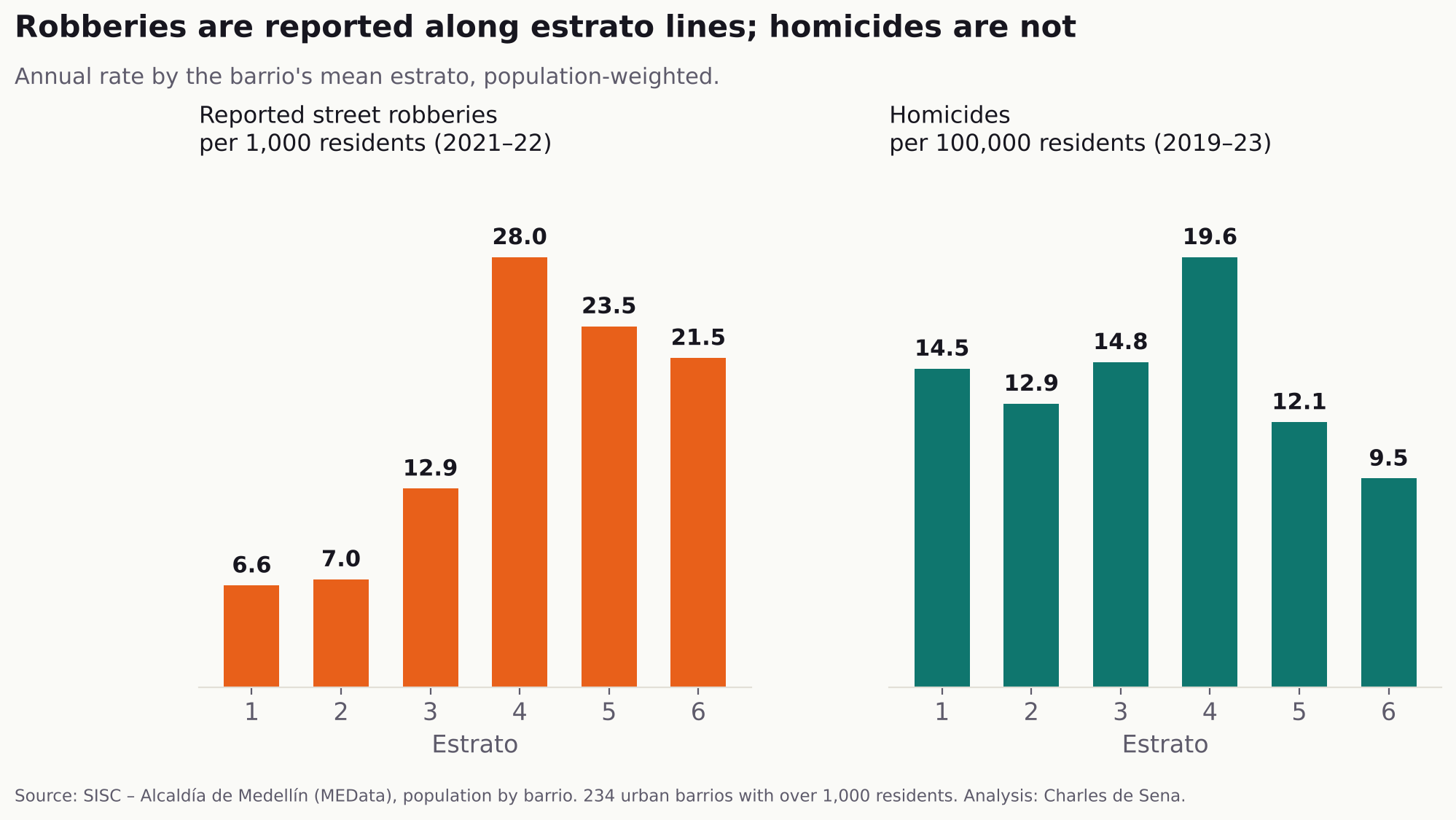
In Colombia, estrato ranks housing from 1 to 6 by socioeconomic conditions. Per 1,000 residents, estrato 4 barrios report four times as many robberies as estrato 1 and 2 barrios. Does that mean El Estadio is more dangerous than Santo Domingo? Not necessarily. People in higher estratos report far more: insurers require a police report, trust in the police is higher, and there are more visitors carrying phones worth stealing. In working-class barrios, many robberies are never reported.
Homicides, on the other hand, are almost always recorded, and their rate doesn’t follow estrato: it stays between 9 and 20 per 100,000 residents at every level. The estrato 4 peak comes from downtown barrios, where many victims don’t live: without comuna 10, the estrato 4 rate drops from 19.6 to 13.9. That’s why the safety score uses homicides only. Robberies appear in each barrio’s profile, with that caveat.
How it was calculated
Each barrio gets a 0–100 score on eight dimensions:
- Safety: homicides per 100,000 residents per year (2019–2023), with a statistical adjustment so small barrios don’t jump because of one or two cases.
- Transit: average distance to the nearest Metro, cable car, tram or Metroplús station.
- Shops: corner stores, markets, pharmacies, restaurants and cafés within 600 meters.
- Health care: clinics, medical offices and Metrosalud centers within 1 km.
- Schools: schools in the barrio and neighboring barrios, plus private schools within 1 km.
- Sports: INDER courts and sports facilities within 1 km.
- Nightlife: bars within 500 meters. Counts for or against you depending on the profile.
- Price: 2025 cadastral land value per m². Cheaper means a better score.
The final score is a weighted geometric mean: a barrio can’t make up for very poor safety with good transit. Only barrios with more than 1,000 residents are scored.
Limits: land value isn’t rent or sale price. Distance to the Metro is a straight line and ignores hills. Business data comes from the tax registry, which leaves out the informal economy. The map doesn’t measure noise, air quality or green space.
Every barrio in Medellín, by comuna
Balanced-profile score. Safety from 0 (worst) to 100 (best).
Comuna 1 – Popular (12 barrios)
| Barrio | Estrato | Balanced score | Safety | Nearest Metro | Land (m², 2025) |
|---|---|---|---|---|---|
| Moscú No.2 | 1.7 | 62 | 86 | 610 m | $0.4M |
| Villa Guadalupe | 1.7 | 60 | 68 | 510 m | $0.5M |
| San Pablo | 1.6 | 60 | 100 | 660 m | $0.5M |
| Santo Domingo Savio No.1 | 1.6 | 54 | 90 | 430 m | $0.5M |
| Granizal | 1.5 | 53 | 52 | 280 m | $0.5M |
| El Compromiso | 1.1 | 52 | 84 | 570 m | $0.3M |
| Popular | 1.5 | 48 | 48 | 620 m | $0.4M |
| Aldea Pablo VI | 1.1 | 44 | 76 | 560 m | $0.3M |
| La Esperanza No.2 | 1.4 | 40 | 36 | 190 m | $0.4M |
| Carpinelo | 1.1 | 33 | 56 | 580 m | $0.3M |
| La Avanzada | 1.2 | 32 | 40 | 430 m | $0.3M |
| Santo Domingo Savio No.2 | 1.2 | 30 | 60 | 730 m | $0.3M |
Comuna 2 – Santa Cruz (11 barrios)
| Barrio | Estrato | Balanced score | Safety | Nearest Metro | Land (m², 2025) |
|---|---|---|---|---|---|
| La Rosa | 1.8 | 62 | 65 | 500 m | $0.6M |
| Andalucía | 1.8 | 60 | 88 | 230 m | $0.6M |
| Villa del Socorro | 1.7 | 57 | 58 | 280 m | $0.5M |
| La Francia | 1.6 | 55 | 65 | 380 m | $0.5M |
| Santa Cruz | 1.6 | 55 | 56 | 620 m | $0.6M |
| Moscú No.1 | 1.7 | 48 | 31 | 520 m | $0.6M |
| La Isla | 1.7 | 48 | 76 | 850 m | $0.5M |
| La Frontera | 1.6 | 48 | 71 | 670 m | $0.5M |
| Pablo VI | 2.0 | 47 | 76 | 650 m | $0.5M |
| Villa Niza | 1.9 | 47 | 44 | 420 m | $0.5M |
| Playón de Los Comuneros | 1.6 | 36 | 55 | 950 m | $0.4M |
Comuna 3 – Manrique (15 barrios)
| Barrio | Estrato | Balanced score | Safety | Nearest Metro | Land (m², 2025) |
|---|---|---|---|---|---|
| El Pomar | 2.3 | 63 | 82 | 310 m | $0.7M |
| La Salle | 1.7 | 62 | 76 | 500 m | $0.5M |
| Santa Inés | 1.7 | 61 | 90 | 770 m | $0.5M |
| Campo Valdés No.2 | 2.4 | 59 | 55 | 310 m | $0.7M |
| Manrique Central No.2 | 2.7 | 55 | 52 | 280 m | $0.7M |
| Las Granjas | 1.7 | 52 | 47 | 570 m | $0.5M |
| El Raizal | 1.4 | 51 | 70 | 1,020 m | $0.6M |
| Manrique Oriental | 2.3 | 50 | 55 | 700 m | $0.7M |
| Versalles No.1 | 1.4 | 46 | 85 | 1,270 m | $0.5M |
| San José La Cima No.2 | 1.4 | 44 | 66 | 1,110 m | $0.2M |
| San José La Cima No.1 | 1.1 | 44 | 60 | 970 m | $0.3M |
| María Cano-Carambolas | 1.1 | 32 | 88 | 1,150 m | $0.3M |
| Versalles No.2 | 1.1 | 28 | 56 | 1,730 m | $0.3M |
| Oriente | 1.3 | 25 | 50 | 1,490 m | $0.3M |
| La Cruz | 1.0 | 18 | 40 | 1,800 m | $0.3M |
Comuna 4 – Aranjuez (14 barrios)
| Barrio | Estrato | Balanced score | Safety | Nearest Metro | Land (m², 2025) |
|---|---|---|---|---|---|
| La Piñuela | 2.5 | 67 | 75 | 330 m | $0.7M |
| San Isidro | 2.4 | 63 | 69 | 410 m | $0.7M |
| Bermejal-Los Álamos | 2.2 | 63 | 87 | 620 m | $0.7M |
| Las Esmeraldas | 2.4 | 61 | 63 | 230 m | $0.7M |
| Campo Valdés No.1 | 2.6 | 60 | 72 | 300 m | $0.8M |
| Berlín | 2.5 | 58 | 44 | 220 m | $0.7M |
| Palermo | 1.8 | 53 | 28 | 400 m | $0.5M |
| Brasilia | 2.5 | 53 | 42 | 620 m | $0.8M |
| Manrique Central No.1 | 2.8 | 47 | 25 | 240 m | $0.8M |
| Moravia | 1.3 | 45 | 25 | 410 m | $0.6M |
| Aranjuez | 2.8 | 42 | 16 | 650 m | $0.8M |
| Miranda | 2.5 | 32 | 3 | 680 m | $0.8M |
| San Pedro | 2.6 | 28 | 0 | 360 m | $0.9M |
| Sevilla | 3.0 | 21 | 0 | 240 m | $2.1M |
Comuna 5 – Castilla (14 barrios)
| Barrio | Estrato | Balanced score | Safety | Nearest Metro | Land (m², 2025) |
|---|---|---|---|---|---|
| Tejelo | 3.0 | 68 | 96 | 1,330 m | $0.7M |
| Alfonso López | 2.4 | 64 | 85 | 1,020 m | $0.8M |
| Castilla | 2.5 | 61 | 47 | 850 m | $0.9M |
| Francisco Antonio Zea | 2.7 | 59 | 51 | 960 m | $0.8M |
| Belalcázar | 2.4 | 56 | 51 | 620 m | $0.8M |
| Tricentenario | 2.9 | 56 | 30 | 330 m | $0.5M |
| Boyacá | 3.0 | 56 | 52 | 870 m | $0.9M |
| Florencia | 3.0 | 55 | 94 | 1,380 m | $0.8M |
| Las Brisas | 2.9 | 48 | 72 | 870 m | $0.7M |
| Toscana | 2.1 | 45 | 67 | 670 m | $0.7M |
| Héctor Abad Gómez | 1.7 | 41 | 15 | 270 m | $0.2M |
| El Progreso | 3.1 | 31 | 14 | 950 m | $2.1M |
| Girardot | 2.7 | 30 | 0 | 920 m | $0.9M |
| Caribe | 3.0 | not scored | – | 750 m | $1.8M |
Comuna 6 – Doce de Octubre (12 barrios)
| Barrio | Estrato | Balanced score | Safety | Nearest Metro | Land (m², 2025) |
|---|---|---|---|---|---|
| La Esperanza | 2.5 | 68 | 83 | 1,380 m | $0.8M |
| San Martín de Porres | 2.4 | 55 | 72 | 1,810 m | $0.6M |
| Pedregal | 2.7 | 53 | 37 | 1,480 m | $0.8M |
| Kennedy | 2.4 | 52 | 61 | 1,850 m | $0.6M |
| Santander | 2.0 | 51 | 62 | 1,970 m | $0.5M |
| Doce de Octubre No.2 | 2.1 | 50 | 47 | 1,970 m | $0.3M |
| Picacho | 1.6 | 42 | 100 | 2,280 m | $0.5M |
| Doce de Octubre No.1 | 1.9 | 38 | 98 | 2,390 m | $0.4M |
| Mirador del Doce | 1.3 | 36 | 90 | 2,490 m | $0.4M |
| Picachito | 1.2 | 29 | 52 | 2,530 m | $0.4M |
| Progreso No.2 | 1.2 | 25 | 80 | 2,720 m | $0.4M |
| El Triunfo | 1.3 | 15 | 62 | 2,980 m | $0.4M |
Comuna 7 – Robledo (22 barrios)
| Barrio | Estrato | Balanced score | Safety | Nearest Metro | Land (m², 2025) |
|---|---|---|---|---|---|
| Altamira | 3.0 | 56 | 76 | 1,350 m | $0.8M |
| San Germán | 3.2 | 55 | 84 | 1,540 m | $0.6M |
| Córdoba | 2.2 | 53 | 48 | 840 m | $1.1M |
| López de Mesa | 3.0 | 50 | 43 | 1,450 m | $1.1M |
| Bosques de San Pablo | 3.7 | 48 | 54 | 1,510 m | $0.8M |
| El Diamante | 2.4 | 48 | 87 | 2,100 m | $1.0M |
| Cucaracho | 2.5 | 44 | 45 | 1,310 m | $0.3M |
| Palenque | 2.9 | 40 | 61 | 2,040 m | $1.1M |
| Pajarito | 2.8 | 40 | 80 | 1,030 m | $0.2M |
| Bello Horizonte | 2.3 | 40 | 77 | 2,280 m | $1.0M |
| Fuente Clara | 1.7 | 39 | 25 | 1,020 m | $0.2M |
| La Pilarica | 4.2 | 39 | 76 | 1,810 m | $2.1M |
| B. Cerro El Volador | 2.2 | not scored | – | 1,460 m | $1.2M |
| Monteclaro | 1.8 | 35 | 64 | 1,770 m | $0.2M |
| Aures No.1 | 2.0 | 35 | 66 | 2,310 m | $0.5M |
| Aures No.2 | 1.9 | 35 | 66 | 2,630 m | $0.5M |
| Facultad de Minas U. Nacional | 3.0 | not scored | – | 1,860 m | $2.0M |
| Villa Flora | 2.5 | 33 | 37 | 2,300 m | $0.6M |
| Santa Margarita | 1.6 | 29 | 55 | 410 m | $0.1M |
| Nueva Villa de La Iguaná | 1.5 | 29 | 0 | 840 m | $0.3M |
| Olaya Herrera | 1.4 | 24 | 33 | 450 m | $0.1M |
| Robledo | 2.5 | 23 | 0 | 1,690 m | $0.5M |
Comuna 8 – Villa Hermosa (18 barrios)
| Barrio | Estrato | Balanced score | Safety | Nearest Metro | Land (m², 2025) |
|---|---|---|---|---|---|
| La Mansión | 2.7 | 65 | 98 | 370 m | $1.1M |
| El Pinal | 1.9 | 63 | 75 | 520 m | $0.5M |
| La Libertad | 1.5 | 62 | 73 | 380 m | $0.5M |
| Villatina | 1.5 | 52 | 43 | 280 m | $0.5M |
| Enciso | 2.3 | 51 | 37 | 850 m | $0.7M |
| Sucre | 2.7 | 51 | 20 | 430 m | $0.8M |
| La Ladera | 2.6 | 50 | 70 | 1,260 m | $0.4M |
| Villa Hermosa | 2.9 | 48 | 74 | 820 m | $1.3M |
| Trece de Noviembre | 1.1 | 46 | 67 | 940 m | $0.3M |
| San Antonio | 1.1 | 44 | 60 | 250 m | $0.3M |
| Los Mangos | 1.8 | 44 | 55 | 1,140 m | $0.6M |
| San Miguel | 3.1 | 43 | 19 | 690 m | $1.3M |
| Batallón Girardot | 3.0 | not scored | – | 1,070 m | $0.8M |
| Las Estancias | 1.4 | 34 | 44 | 430 m | $0.4M |
| Llanaditas | 1.1 | 24 | 58 | 1,590 m | $0.3M |
| Villa Lilliam | 1.5 | 16 | 4 | 340 m | $0.4M |
| Villa Turbay | 1.0 | 14 | 16 | 320 m | $0.3M |
| La Sierra | 1.1 | 10 | 6 | 260 m | $0.3M |
Comuna 9 – Buenos Aires (17 barrios)
| Barrio | Estrato | Balanced score | Safety | Nearest Metro | Land (m², 2025) |
|---|---|---|---|---|---|
| Gerona | 2.7 | 63 | 68 | 570 m | $1.4M |
| El Salvador | 2.7 | 63 | 79 | 760 m | $1.2M |
| Miraflores | 3.2 | 62 | 61 | 460 m | $1.2M |
| Cataluña | 3.0 | 62 | 94 | 1,070 m | $0.5M |
| Los Cerros El Vergel | 2.8 | 61 | 64 | 350 m | $0.8M |
| Buenos Aires | 2.9 | 61 | 48 | 250 m | $1.4M |
| Barrio Caicedo | 2.8 | 59 | 41 | 210 m | $1.4M |
| Loreto | 2.4 | 58 | 85 | 1,200 m | $0.7M |
| Alejandro Echavarría | 2.8 | 57 | 29 | 150 m | $0.3M |
| La Milagrosa | 3.0 | 57 | 53 | 660 m | $1.4M |
| Bomboná No.2 | 2.5 | 55 | 100 | 770 m | $0.5M |
| Asomadera No.1 | 2.8 | 55 | 81 | 850 m | $1.2M |
| Barrios de Jesús | 1.9 | 53 | 100 | 520 m | $0.5M |
| Asomadera No.2 | 5.1 | 26 | 23 | 1,380 m | $1.2M |
| Asomadera No.3 | 5.2 | not scored | – | 1,730 m | $1.2M |
| Juan Pablo II | 1.5 | 16 | 37 | 630 m | $0.4M |
| Ocho de Marzo | 1.3 | 16 | 51 | 760 m | $0.4M |
Comuna 10 – La Candelaria (17 barrios)
| Barrio | Estrato | Balanced score | Safety | Nearest Metro | Land (m², 2025) |
|---|---|---|---|---|---|
| Los Ángeles | 3.8 | 52 | 46 | 490 m | $1.8M |
| Las Palmas | 2.6 | 51 | 39 | 510 m | $1.7M |
| Bomboná No.1 | 3.5 | 48 | 58 | 230 m | $2.9M |
| Boston | 3.7 | 47 | 28 | 370 m | $2.1M |
| San Diego | 3.7 | 43 | 44 | 360 m | $2.3M |
| Corazón de Jesús | 3.9 | 30 | 20 | 320 m | $3.4M |
| Prado | 3.8 | 26 | 0 | 270 m | $1.5M |
| El Chagualo | 3.0 | 24 | 9 | 270 m | $2.9M |
| Barrio Colón | 2.8 | 22 | 0 | 210 m | $3.8M |
| Calle Nueva | 3.9 | not scored | – | 180 m | $4.3M |
| Jesús Nazareno | 3.1 | 21 | 0 | 190 m | $2.4M |
| Estación Villa | 3.0 | not scored | – | 290 m | $2.6M |
| Villa Nueva | 3.9 | 21 | 0 | 200 m | $2.6M |
| San Benito | 3.1 | not scored | – | 280 m | $3.1M |
| Guayaquil | 3.0 | not scored | – | 210 m | $8.3M |
| La Candelaria | 3.9 | 18 | 0 | 170 m | $6.7M |
| Perpetuo Socorro | 3.0 | not scored | – | 260 m | $4.3M |
Comuna 11 – Laureles Estadio (15 barrios)
| Barrio | Estrato | Balanced score | Safety | Nearest Metro | Land (m², 2025) |
|---|---|---|---|---|---|
| Los Colores | 4.4 | 62 | 100 | 1,040 m | $2.2M |
| El Velódromo | 4.8 | 57 | 55 | 520 m | $2.6M |
| Florida Nueva | 4.6 | 56 | 58 | 400 m | $2.6M |
| Estadio | 4.9 | 50 | 36 | 450 m | $2.6M |
| San Joaquín | 4.1 | 49 | 57 | 770 m | $2.5M |
| La Castellana | 5.0 | 49 | 97 | 1,100 m | $2.6M |
| Lorena | 4.6 | 48 | 46 | 1,090 m | $2.6M |
| Bolivariana | 4.5 | 47 | 46 | 820 m | $3.1M |
| Cuarta Brigada | 3.9 | 46 | 38 | 880 m | $2.6M |
| Carlos E. Restrepo | 4.0 | 45 | 32 | 570 m | $2.2M |
| Los Conquistadores | 5.0 | 44 | 62 | 800 m | $2.8M |
| Las Acacias | 4.8 | 39 | 42 | 1,120 m | $2.6M |
| Laureles | 5.0 | 39 | 45 | 1,150 m | $2.8M |
| Suramericana | 4.8 | 27 | 1 | 330 m | $2.7M |
| Naranjal | 4.0 | 25 | 0 | 320 m | $2.9M |
Comuna 12 – La América (13 barrios)
| Barrio | Estrato | Balanced score | Safety | Nearest Metro | Land (m², 2025) |
|---|---|---|---|---|---|
| La América | 3.7 | 63 | 69 | 740 m | $1.9M |
| Barrio Cristóbal | 3.4 | 59 | 76 | 1,110 m | $1.7M |
| La Floresta | 3.8 | 58 | 37 | 310 m | $1.9M |
| Campo Alegre | 3.5 | 58 | 45 | 440 m | $1.4M |
| Calasanz | 4.8 | 56 | 42 | 480 m | $1.9M |
| Calasanz Parte Alta | 3.4 | 54 | 100 | 900 m | $1.9M |
| Los Pinos | 4.3 | 53 | 33 | 730 m | $2.2M |
| Simón Bolívar | 4.8 | 53 | 65 | 1,330 m | $2.0M |
| El Danubio | 3.7 | 50 | 25 | 630 m | $1.6M |
| Santa Teresita | 4.5 | 50 | 89 | 1,400 m | $2.0M |
| Santa Lucía | 3.2 | 50 | 26 | 300 m | $1.6M |
| Santa Mónica | 4.0 | 45 | 34 | 990 m | $1.9M |
| Ferrini | 3.6 | 42 | 38 | 1,150 m | $1.9M |
Comuna 13 – San Javier (19 barrios)
| Barrio | Estrato | Balanced score | Safety | Nearest Metro | Land (m², 2025) |
|---|---|---|---|---|---|
| Los Alcázares | 3.3 | 58 | 59 | 410 m | $1.6M |
| San Javier No.2 | 3.3 | 57 | 57 | 200 m | $1.4M |
| Belencito | 3.7 | 57 | 58 | 1,020 m | $0.6M |
| Veinte de Julio | 1.8 | 53 | 43 | 990 m | $0.6M |
| La Pradera | 2.5 | 50 | 34 | 480 m | $0.9M |
| Antonio Nariño | 1.9 | 48 | 40 | 890 m | $0.3M |
| El Socorro | 2.1 | 47 | 37 | 600 m | $0.3M |
| Metropolitano | 2.0 | 46 | 43 | 580 m | $0.5M |
| El Pesebre | 1.4 | 46 | 29 | 1,450 m | $0.2M |
| Santa Rosa de Lima | 2.5 | 45 | 37 | 730 m | $0.5M |
| El Salado | 1.4 | 42 | 72 | 1,510 m | $0.2M |
| Blanquizal | 1.2 | 42 | 66 | 930 m | $0.2M |
| San Javier No.1 | 3.0 | 42 | 17 | 430 m | $1.4M |
| Las Independencias | 1.1 | 38 | 28 | 1,390 m | $0.3M |
| Juan XXIII La Quiebra | 1.3 | 34 | 69 | 240 m | $0.3M |
| Betania | 1.9 | 34 | 26 | 1,580 m | $0.5M |
| Nuevos Conquistadores | 1.1 | 29 | 51 | 1,750 m | $0.2M |
| Eduardo Santos | 2.0 | 22 | 71 | 1,640 m | $0.2M |
| El Corazón | 1.6 | 17 | 20 | 1,840 m | $0.5M |
Comuna 14 – El Poblado (22 barrios)
| Barrio | Estrato | Balanced score | Safety | Nearest Metro | Land (m², 2025) |
|---|---|---|---|---|---|
| Patio Bonito | 5.8 | 35 | 38 | 710 m | $2.6M |
| Villa Carlota | 4.9 | 35 | 75 | 770 m | $4.5M |
| Lalinde | 5.8 | 35 | 73 | 1,230 m | $2.8M |
| Los Balsos No.2 | 5.9 | 34 | 98 | 1,300 m | $2.8M |
| Santa María de Los Ángeles | 5.8 | 33 | 100 | 480 m | $2.6M |
| Castropol | 5.8 | 33 | 80 | 1,060 m | $2.8M |
| La Florida | 5.2 | 33 | 76 | 1,590 m | $2.8M |
| La Aguacatala | 5.9 | 32 | 54 | 750 m | $3.8M |
| El Castillo | 6.0 | 32 | 67 | 1,140 m | $2.2M |
| Manila | 4.1 | not scored | – | 580 m | $4.5M |
| Las Lomas No.1 | 5.7 | 30 | 75 | 1,780 m | $2.8M |
| Alejandría | 4.6 | 28 | 48 | 1,570 m | $2.8M |
| El Diamante No.2 | 5.6 | 27 | 100 | 1,280 m | $2.6M |
| El Poblado | 4.2 | not scored | – | 1,170 m | $5.6M |
| El Tesoro | 4.9 | 24 | 100 | 2,670 m | $2.5M |
| Barrio Colombia | 3.1 | not scored | – | 270 m | $4.5M |
| Astorga | 5.1 | not scored | – | 580 m | $5.2M |
| Los Naranjos | 4.1 | 22 | 63 | 2,540 m | $2.5M |
| Las Lomas No.2 | 5.8 | 20 | 58 | 2,300 m | $2.5M |
| Los Balsos No.1 | 5.4 | 19 | 100 | 2,430 m | $2.8M |
| Altos del Poblado | 5.4 | 17 | 69 | 2,600 m | $2.1M |
| San Lucas | 5.0 | 17 | 100 | 2,320 m | $2.8M |
Comuna 15 – Guayabal (7 barrios)
| Barrio | Estrato | Balanced score | Safety | Nearest Metro | Land (m², 2025) |
|---|---|---|---|---|---|
| Trinidad | 3.0 | 49 | 28 | 460 m | $1.5M |
| Cristo Rey | 3.3 | 43 | 38 | 1,030 m | $2.1M |
| Santa Fé | 4.0 | 43 | 33 | 840 m | $1.9M |
| La Colina | 2.5 | 34 | 40 | 1,430 m | $1.2M |
| Campo Amor | 3.7 | 32 | 14 | 610 m | $2.6M |
| Guayabal | 3.3 | 29 | 23 | 780 m | $2.7M |
| Tenche | 3.0 | not scored | – | 210 m | $3.1M |
Comuna 16 – Belén (21 barrios)
| Barrio | Estrato | Balanced score | Safety | Nearest Metro | Land (m², 2025) |
|---|---|---|---|---|---|
| San Bernardo | 3.2 | 64 | 71 | 610 m | $1.9M |
| Las Mercedes | 2.8 | 63 | 100 | 630 m | $0.8M |
| Fátima | 3.7 | 59 | 65 | 460 m | $2.1M |
| Rosales | 4.7 | 59 | 49 | 470 m | $2.1M |
| Granada | 3.4 | 58 | 44 | 240 m | $2.3M |
| La Loma de Los Bernal | 4.1 | 57 | 97 | 1,390 m | $1.9M |
| La Gloria | 3.7 | 57 | 67 | 890 m | $1.9M |
| Cerro Nutibara | 4.2 | 56 | 68 | 650 m | $1.2M |
| Miravalle | 4.2 | 55 | 83 | 520 m | $2.4M |
| Las Playas | 3.1 | 54 | 53 | 1,200 m | $1.9M |
| Belén | 3.7 | 53 | 41 | 240 m | $2.4M |
| La Palma | 4.3 | 53 | 44 | 270 m | $2.3M |
| Nueva Villa del Aburrá | 4.7 | 52 | 48 | 530 m | $2.1M |
| Diego Echavarría | 4.3 | 51 | 93 | 1,690 m | $2.1M |
| Los Alpes | 3.1 | 48 | 34 | 200 m | $1.9M |
| La Mota | 3.4 | 46 | 100 | 2,110 m | $1.9M |
| El Nogal-Los Almendros | 4.6 | 44 | 27 | 670 m | $2.4M |
| Las Violetas | 2.0 | 41 | 42 | 620 m | $0.4M |
| El Rincón | 2.1 | 30 | 34 | 2,260 m | $0.9M |
| Altavista | 2.2 | 29 | 0 | 720 m | $0.5M |
| La Hondonada | 2.4 | 19 | 53 | 2,530 m | $1.0M |
Sources
- City of Medellín (MEData): homicides (2019–2023), street robberies (2021–2022) and home burglaries (2020–2022) from SISC; Metrosalud health centers; INDER sports facilities; the official school directory. CC BY-SA 4.0 license.
- City of Medellín (GeoMedellín): barrio boundaries (POT), 2025 land-value zones, business registry, estrato by city block and population by barrio.
- Metro de Medellín: system stations (GTFS published in the ColombiaGTFS repository).
The charts and the map may be reproduced by media outlets with credit: Analysis: Charles de Sena using open data from the City of Medellín.
Moving to Medellín, investing in property or running a business and want this analysis for a specific area? See the Real Estate Intelligence service or message me on WhatsApp.